When Getting Lost Was Part of the Adventure — Before Your Phone Became Your Navigator
When Getting Lost Was Part of the Adventure — Before Your Phone Became Your Navigator
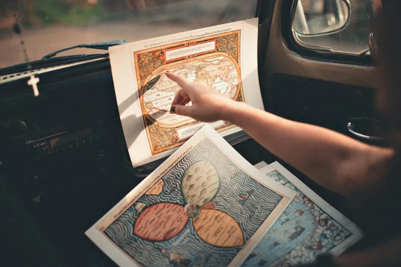
Picture this: It's 1985, and you're planning a cross-country road trip from New York to Los Angeles. Your preparation doesn't involve downloading an app or checking real-time traffic. Instead, you spread out a Rand McNally atlas across your kitchen table — a massive, unwieldy thing that unfolds like an accordion and covers half the surface. You trace routes with your finger, highlight highways with a yellow marker, and write down exit numbers on scraps of paper.
Getting lost wasn't a malfunction. It was expected.
The Sacred Ritual of Map Reading
Before smartphones turned us all into passive passengers in our own journeys, Americans possessed a skill that's now as obsolete as cursive handwriting: reading maps. Not the sanitized, zoomed-in snippets we glance at today, but real maps — those enormous, crinkly sheets that required genuine spatial intelligence to decode.
Every gas station sold them. Every glove compartment contained at least one, usually several, in various states of wear. AAA TripTiks were treasures, custom-made spiral-bound route guides that felt like receiving a personalized blueprint for adventure. You'd call AAA, explain your destination, and wait for them to mail you a booklet showing your exact route, complete with suggested stops and local attractions.
Folding these maps back correctly was an art form. Get it wrong, and you'd spend ten minutes wrestling with what felt like a paper octopus while your passenger offered unhelpful suggestions. Most Americans eventually gave up on proper folding, stuffing crumpled maps into door pockets like automotive origami failures.
When Navigation Required Actual Skills
Using a paper map demanded skills we've collectively forgotten. You had to understand scale, estimate distances, and mentally rotate your perspective to match the road you were traveling. You learned to read terrain — understanding that those squiggly lines meant mountains and slower driving, that blue areas meant water crossings, that tiny numbers indicated elevation changes.
More importantly, you had to think ahead. Running out of gas in 1985 meant more than a minor inconvenience; it meant being genuinely stranded. So you studied your route, identified gas stations, and planned rest stops. You became intimately familiar with your path before you ever started the engine.
Navigating required a co-pilot, someone to handle the map while you drove. This created a unique form of teamwork — and occasional marital tension. "Turn left at the next intersection" was often met with "Which intersection?" followed by frantic map rustling and heated discussions about whether that cluster of buildings ahead constituted a "town" or just a "settlement."
The Death of Geographic Intuition
Today, most Americans couldn't find their way across their own city without GPS guidance. We've traded geographic literacy for convenience, and the exchange rate wasn't favorable.
Modern navigation has made us spatially helpless. We follow blue lines on screens without understanding where we're going or how we got there. We've outsourced our sense of direction to satellites, and most of us couldn't estimate travel time or distance without consulting our phones.
The average smartphone user checks their GPS even for familiar routes, just to see traffic conditions. We've become dependent on real-time updates, unable to function when the signal drops or the battery dies. The phrase "I'm lost" has evolved from "I don't know where I am" to "my phone doesn't have service."
What We Lost in the Translation
The shift from paper maps to GPS navigation represents more than technological progress — it's a fundamental change in how Americans relate to space and place. Paper maps forced us to understand geography. We learned state shapes, major cities, and highway systems. We developed an intuitive sense of direction and distance that GPS has quietly erased.
Getting lost with a paper map was frustrating but educational. You'd stop at gas stations, ask locals for directions, and often discover interesting detours. These unplanned encounters — the roadside diner recommended by a stranger, the scenic overlook you stumbled upon while backtracking — became the best parts of the journey.
Modern GPS eliminates these accidents. It calculates the most efficient route and keeps you locked onto it, steering you past experiences you'll never know you missed.
The Convenience Revolution
None of this is to suggest that GPS isn't remarkable. Today's navigation technology would seem like magic to a 1985 traveler. Real-time traffic updates, automatic rerouting around accidents, and precise arrival times have made driving immeasurably more efficient.
You can now navigate to any address in America without owning a single map. Your phone knows exactly where you are at any moment and can guide you to any destination with turn-by-turn precision. It warns you about speed traps, suggests faster routes, and even tells you which lane to use for upcoming exits.
The Gap We Didn't Notice
The transformation from paper maps to GPS happened gradually, then suddenly. One day we were folding maps; the next day we were following blue dots on screens. Most Americans didn't notice what we lost in the transition: the ability to navigate independently, to understand our geographic relationship to the world around us, and to find adventure in the spaces between destinations.
We gained efficiency and lost exploration. We gained convenience and lost competence. We gained connectivity and lost the quiet satisfaction of figuring things out for ourselves.
The next time your GPS loses signal, notice what happens. Most of us panic slightly, suddenly aware of how dependent we've become on external guidance for something as basic as finding our way home.
That moment of helplessness? That's the gap we didn't see coming.